Last Updated on June 26, 2025 by Audrey Scott
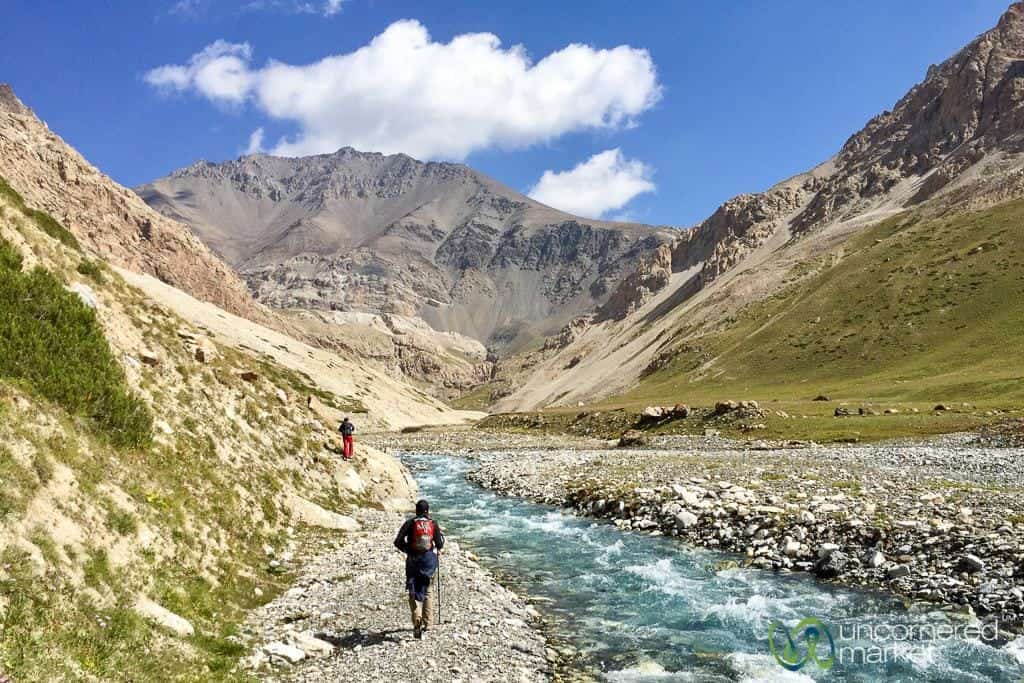
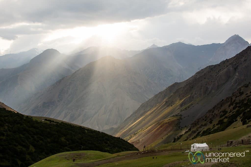
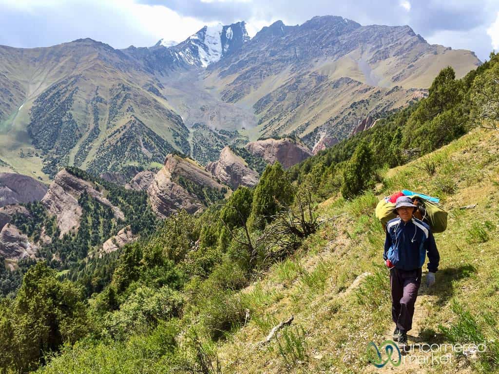
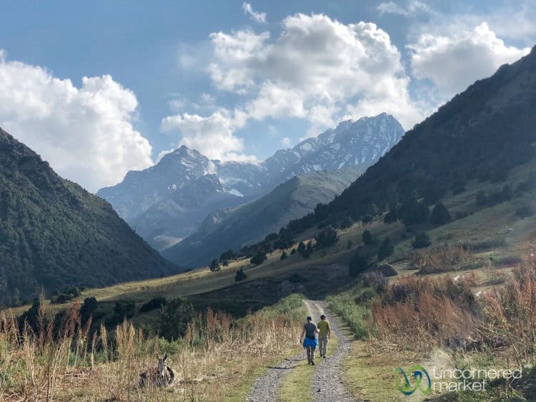
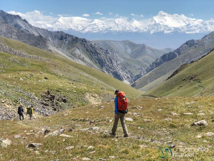
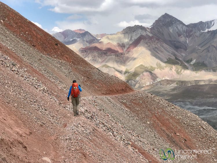
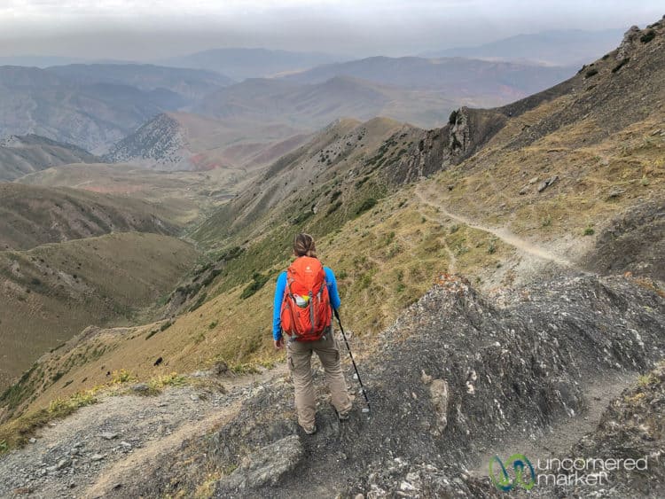
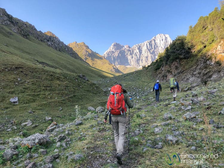
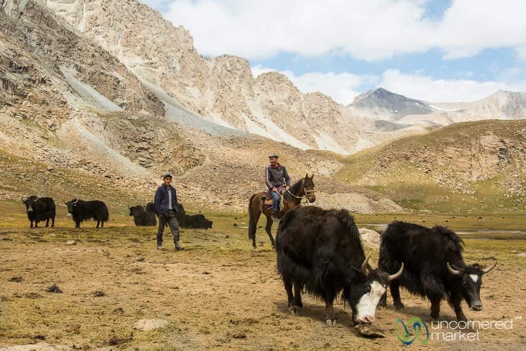
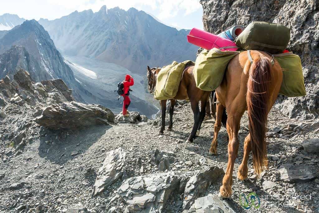
Striding toward the Pamir Mountain range-line on the horizon, I chased the waning light across a broad meadow dotted with horses in the distance. We'd descended from a mountain pass surrounded by turquoise alpine lakes and defined by glacier ridge lines. Yak herders we met earlier invited us into their yurt for tea and local specialties, a gesture typical of Kyrgyz nomadic culture and hospitality.
This is trekking in the Alay Mountains of southern Kyrgyzstan.
The Alay Mountains (or what some also referred to as the Alay Valley) are a sub-range of the towering Pamir-Alay Mountain system which sit in Kyrgyzstan and Tajikistan north of the Hindu Kush and Himalayas. Trekking experiences run from the day hike variety where you can experience some of the area’s alpine lakes, snow-covered peak panoramas and cultural highlights in a single day to varied multi-day treks that deliver otherworldly views, remoteness and some of the most worthwhile trekking Kyrgyzstan has to offer.
And, you'll likely have the trails all to yourself as this mountain region is still a relatively unknown.
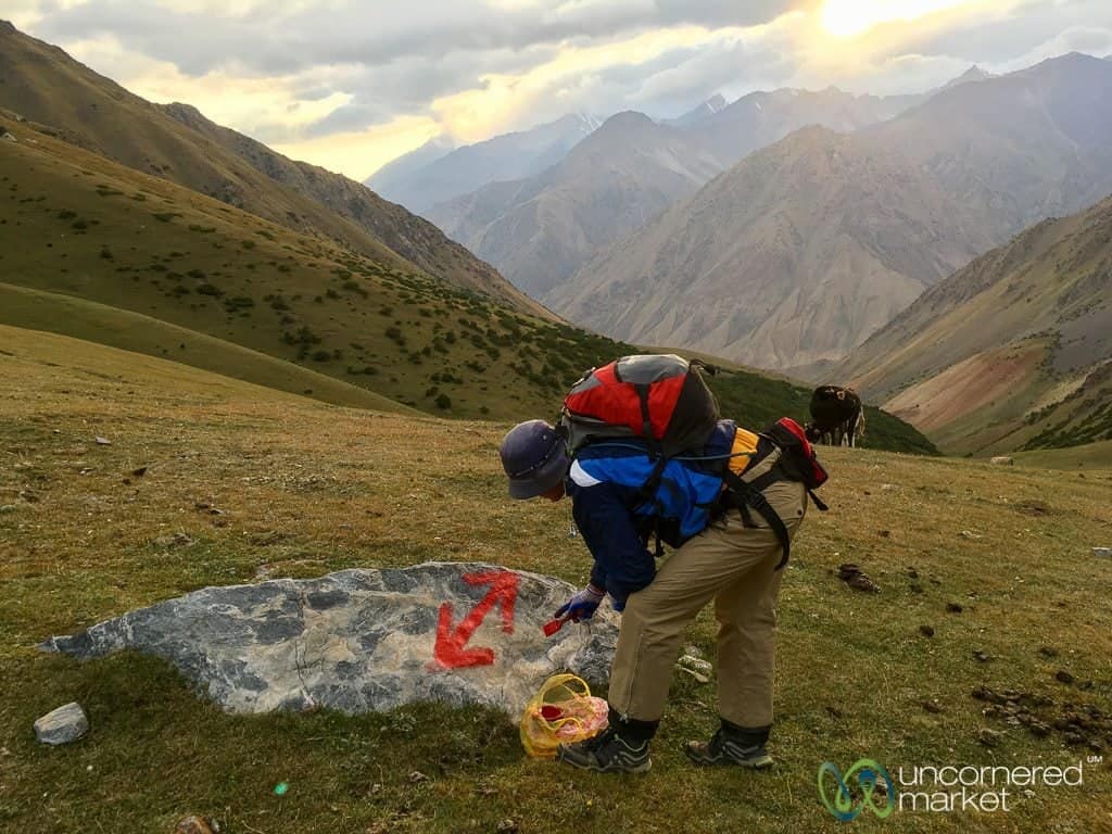
Prior to our visit where we helped mark new trekking trails in the area, we didn’t know much of the Alay trekking corridor. After our experience, we are fan-evangelists.
This article explains why and how to easily organize and do Alay Mountain day hikes and the multi-day treks.
Update September 2019:: We returned to the Alay Region in August 2019 on a tourism development project to test other existing and emerging treks in both the Alay Mountains and Pamir Mountains. This article has been updated accordingly with even more trekking options and details.
Note: French speakers, you can now find a French translation of this Alay Trekking Guide here!
Note: There's a battle between transliterated spellings of what we call Sary Mogul (town and pass). You might see it elsewhere also as Sary Mogol, and also Sary Moghul. Sorry (ahem) for any confusion.
Table of Contents
Choosing a Trek in the Alay Mountains
There are many different trekking choices in the Alay Mountain sub-range in southern Kyrgyzstan, but you really can't go wrong no matter what you choose.
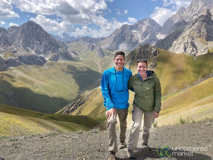
Your choice of trek will depend on how many days you have, how remote you'd like to be, the difficulty and altitude level you seek, and how much culture or interaction with local people you want. Whether your trek is the main reason for your journey to southern Kyrgyzstan or if you are interested in incorporating a trek as part of your journey along the Pamir Highway to/from Tajikistan, there are endless variations of treks you can take in the Alay Mountains ranging from one-day hikes to 6-10 day treks.
Some of the more popular treks in the Alay Mountains and Alay Valley include:
- Best of Alay Mountains (8 days): This is essentially the two multi-day treks we did combined into one. We outline it below in detail. Highly recommended. Stunning landscapes and views. During our first visit, we were only able to do the shorter version from Sary Mogul to Kojokelen village. During our second visit we completed the trek, which includes crossing Jiptick Pass back to Sary Mogul, up to Tulpar Kol Lake yurt camp and then a hike to Traveller's Pass with beautiful views of Lenin Peak and the other-worldly mountain landscapes. Note: If you don't have as much time, you can do a shorter version with the Heights of Alay Trek (5 days) or Heights of Alay Valley Trek (6 days). The difference is that your trek ends in Sary Mogul.
- Lenin Peak Base Camp to Traveler’s Pass Trek and Yuhina Peak: Although this trek is technically in the Pamir Mountains and not the Alay Mountains, we include it here since it's a pretty incredible high altitude hike. It begins at the yurt camp at Tulpar-Kol lake near Lenin Peak Base Camp and goes up to Traveler's Pass (4,130 meters). While most people turn around and go down again, this trek continues on from Traveler’s Pass to overnight at Camp 1 (4,400 meters/14,435 ft). The next morning”s hike goes up to Yuhina Peak (5,100 meters/16,730 feet) for more stunning views. After lunch at Camp 1 return the same way to Tulpar-Kol yurt camp for the night before returning to Sary Mogul. Transport is required from Sary Mogul to Tulpar-Kol Lake and back again. This is part of the Lenin Peak Base Camp Trek (8 days) that also includes Sary Mogul and Jiptick passes mentioned above. See below for more details and photos.
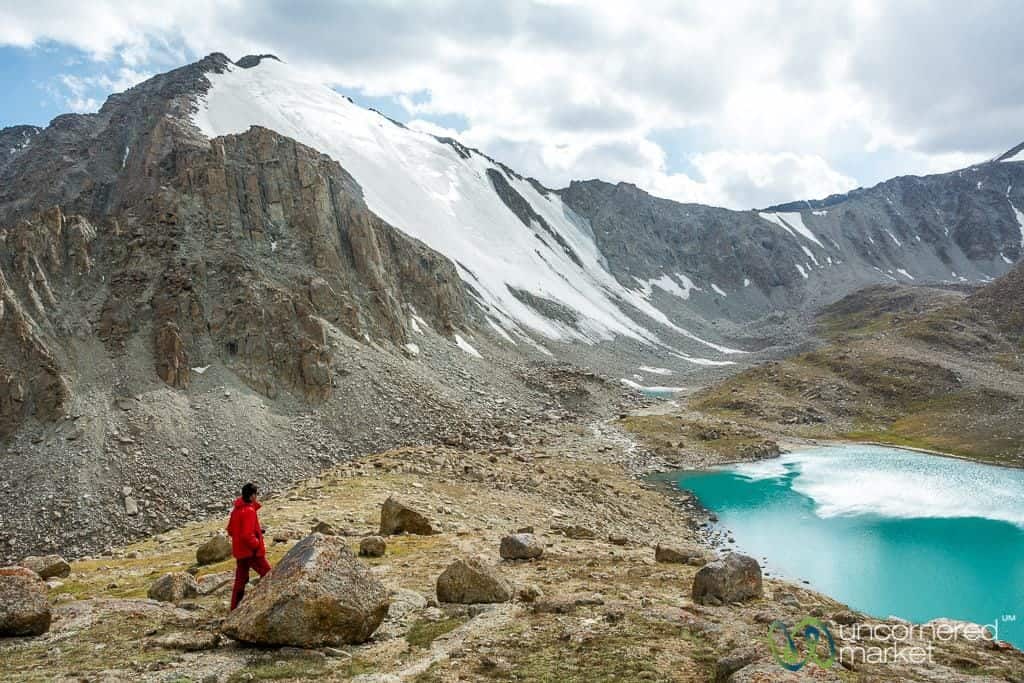
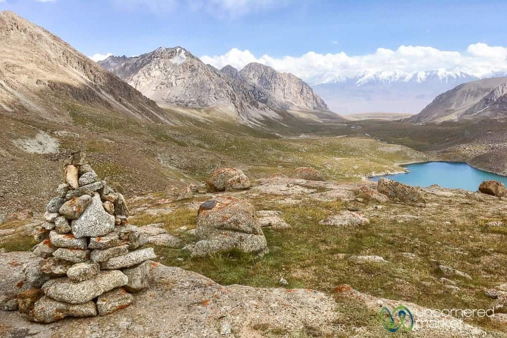
- Koshkol Lakes Trek (1 day): A fabulous one-day trek we did from Sary Mogul. This trek takes you from a local shepherd yurt camp through a valley filled with yaks, over several passes to the height of 4,195 meters where you'll have views of four alpine lakes, glaciers, and the Pamir Mountains in the distance. More details below. View the GPS tracks here.
- Scenic Ak-Tor Pass Trek (2-5 days): This trek in the lower Alay Mountains has several different options and lengths, from two to five days and either on foot or on horse. We did the three-day version on foot (25 miles/40 km) and were pleasantly surprised by the change in landscapes, from layers of hills to green valleys filled with grazing animals to impressive granite peaks. The highlight is crossing Ak-Tor Pass at 3,500 meters/11,500 feet, and the sweeping and deep panoramic views of the Alay Mountain range. We also recommended this trek as an acclimatization trek if you plan to go into the high Alay or Pamir mountains. The trailhead is not far from Gulcha and about an hour outside of Osh. See the day by day detail below.
- Truly Nomadic Lands (5 days): A challenging trek — either by horse or on foot — that not only features magnificent mountain panoramas, but also Kyrgyzstan's nomadic culture as there are many shepherd yurt camps along this trail. The start of this trail is about an hour from Osh. View the GPS tracks here.
- Ak-Bosogo — Sary-Mogul Trek (1 day): Starting just off the Pamir Highway, this day hike takes you through jailoos (high summer pastures) until you reach Algachart Pass, where you can enjoy views of the Pamir-Alay Mountains. Transport required. View the GPS tracks here.
- Treks in Kyrgyz-Ata National Park: This is a good option for those who still want to do a bit of trekking and experience the Alay Mountains, but don't want to go far from Osh city. After a day trek it's possible to return to Osh the same day or to spend the night at one of the local yurt camps.
You can find a comprehensive list of trekking options for the Alay Mountains and valleys here.
Best of Alay Trek: What to Expect on a Multi-Day Trek in the High Alay Mountains
This trek is one of the favorite we've done over the last few years. At 8 days with Best of Alay or even at the shorter 5-6 day Heights of Alay Trek, this hiking route packs an experiential punch. Each day takes you through different landscapes, over mountain passes and includes interactions with local shepherds and villagers. However, the first day's cross of Sary Mogul Pass really stands out; you'll feel as if you've landed on a different planet.
2019 Update: The Best of Alay / Heights of Alay Trek is now fully connected by family yurt camps or guesthouses. This means more engagement with local people and no need to carry tents and camping equipment.
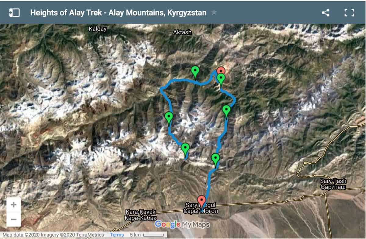
Note: The Best of Alay Trek and full Heights of Alay Trek is 5 nights/6 days (87 km), takes you over Jiptick Pass and ends in Sary Mogul village. During our first visit we did an abbreviated version that ends in Kojokelen village. On our second visit we picked up the trail from Kojokelen village over Jiptick Pass (4,185 meters/13,730 feet) with stunning views of the snow-covered Pamir Mountains and Peak Lenin. If you have the time we'd recommend doing the full trek. However, if you only have four days then we recommend doing the first part of the trek over Sary Mogul Pass to Kojokelen village.
Our Route: Sary Mogul Village – Beshkol Lakes – Sary Mogul Pass – Kyzylshoro village – Koshmoinok Pass – Koshmoinok Valley – Sarybell Pass – Kojokelen village
Total Hiking Distance: 48 km / 30 miles
Number of Days: 5 nights/6 days (if you do the shorter version of the trek you’ll transfer to Osh at the end of day 3 or on day 4)
Minimum / Maximum Altitude: 2,186 m (7,170 feet) / 4,303 m (14,120 feet)
Season: mid/late June – early September
Difficulty: Medium
Day 1: Sary Mogul Village – Beshkol Lakes – Sary Mogul Pass – Campsite
Hiking Distance: 14 km / 8.7 miles
Minimum / Maximum Altitude: 3,369 m (11,050 feet) / 4,303 m (14,120 feet)
Number of hours hiking: 5-6 hours
Difficulty: Medium
We don't want to oversell the views and experience on this day, but if the weather is clear it will certainly be memorable. You cover a lot of ground and elevation (up to 4,303 meters), but it's a relatively steady incline so you don't feel completely exhausted by day's end.
The starting point of the trek is around 15 km northeast of Sary Mogul village. You'll need to arrange a transfer in advance to take you there in the morning. From there, follow the shepherd paths towards the stream and up the valley. After a while there's a short stretch where the trail is narrow, difficult to see, and the terrain is composed mainly of scree and small pebbles. It's a bit challenging already when it's dry, so we suggest not to attempt this approach in the rain or when the trail is wet.
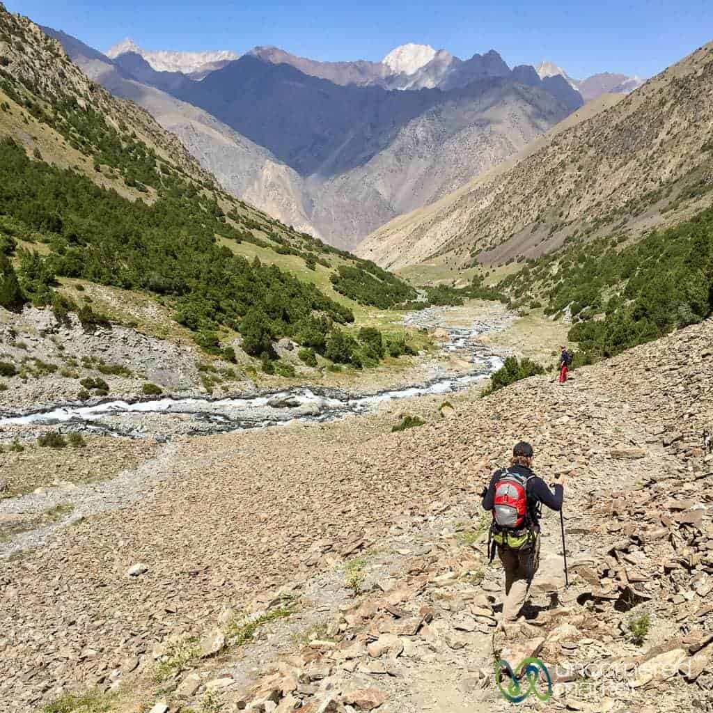
Within a couple of hours you'll cross a small pass and leave the river valley behind you. Before you do, be sure to look back for great views of Peak Lenin and the Pamir Mountains behind you. You'll then descend into a second river valley with rocky and high desert terrain.
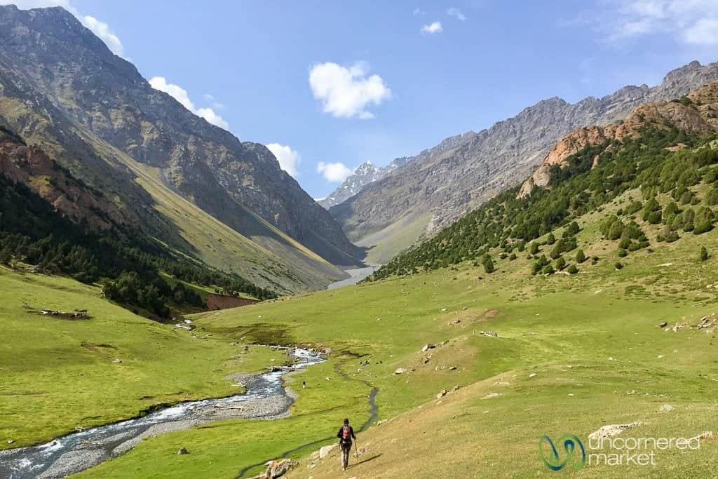
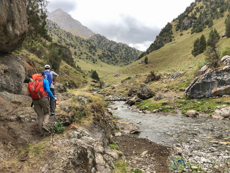
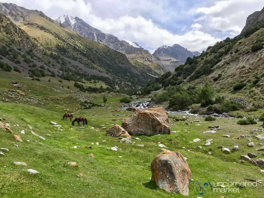
Follow the stream through the valley. Eventually the path will take you over the hills and into another river valley, this one even greener and more lush than the previous one. This is a good spot for a snack or lunch as there is a good water source, protection from wind, and glacier views.
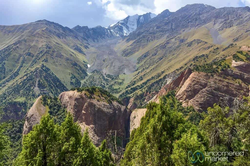
Then comes the big ascent towards Sary Mogul Pass. As you climb higher, the landscape opens; peaks, glaciers and alpine lakes begin to appear. Soak in the views around you and of the Pamir Mountains in the distance before making the final push up a steep volcanic rock- and scree-covered incline.
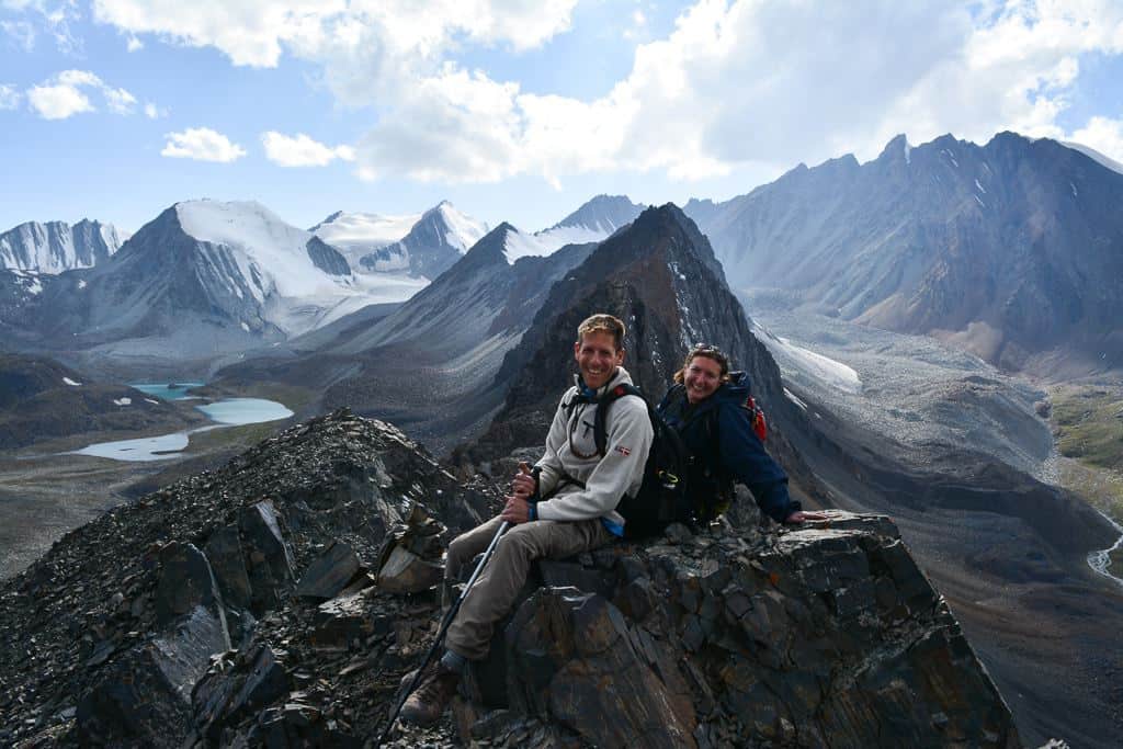
Once you reach Sary Mogul Pass at 4,303 meters / 14,120 feet, the highest point of this trek, take some time to enjoy your accomplishment and climb all over the rocks. The views from up here of the expansive peak, glacier and alpine lake are incredible and otherworldly.
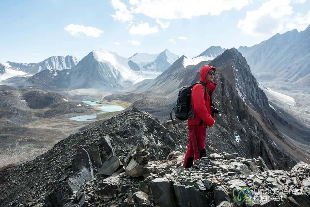
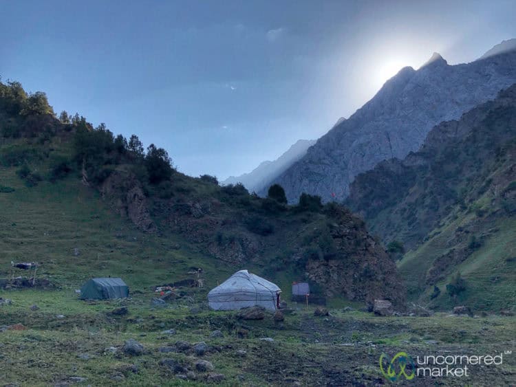
From there, it's a steep descent through scree to the campsite/yurt camp located below (39°52'37.97”N 72°48'11.45”E) near the stream. Bundle up, as it can turn especially cold here at night given the elevation (3,900 meters / 12,800 feet). Update: There is now a family yurt camp available for trekkers to stay at the base of the pass so there’s no longer any need to carry tents, food or other camping gear.
Day 2: Campsite/Yurt Camp – Kyzyl Shoro village
Update 2019: The trek now overnights in Kyzyl Shoro vs. continuing over Koshmoinok Pass and Valley as we originally did. The details have been updated accordingly.
Hiking Distance: 10 km / 6 miles
Minimum / Maximum Altitude: 2,387 m (7,830 feet)
Number of hours hiking: 4-5 hours
The start of the second day is relatively easy going and mainly downhill towards little Sary Mogul and Kyzylshoro villages.
From the campsite/yurt camp, follow the trail through the valley and along the river. With the decline in elevation, the terrain begins to change from high alpine rocky and sparse to mid-mountain green dotted with the alpine lush of juniper bushes. You'll have views of the surrounding glaciers and snow-covered peaks above and behind you.
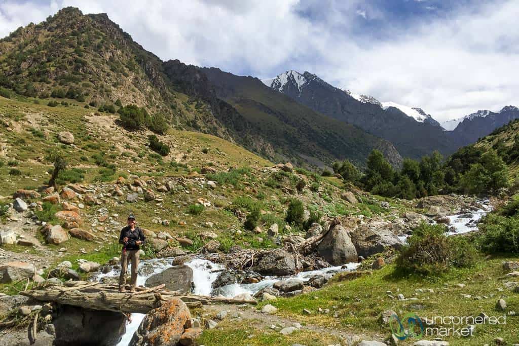
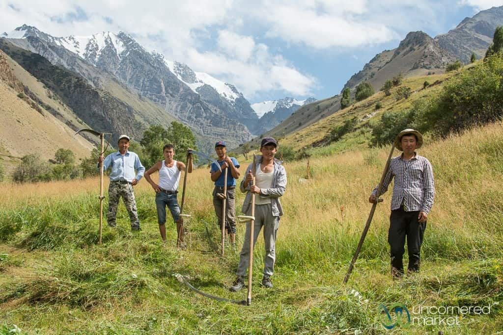
The trail rises a bit and continues through the hills, staying parallel to the river, until it reaches the farmlands of the nearby village, Little Sary Mogul. When we did our trek at the end of August it was hay-making season, so many in the village were out in the fields cutting the long grass in preparation for the winter season ahead.
As you continue through Little Sary Mogul village, don't be surprised if you receive some invitations for tea along the way — including from a friendly grandfather, as we did. The next stretch is perhaps the least pleasant of the journey, as it winds along a dusty road shared with cars and trucks. You'll pass another small village of Kyzyl Shoro where you can pick up additional food supplies at the guest house in town. Update: The trek now overnights here in Kyzyl Shoro village at a guesthouse.
Day 3: Kyzyl Shoro Village – Koshmoinok valley – Sarybell Pass – Kojokelen village
Hiking Distance: 25 km / 16 miles
Minimum / Maximum Altitude: 2,223 m (7,293 feet) / 3,415 m (11,205 feet)
Estimated number of hours: 8-9 hours
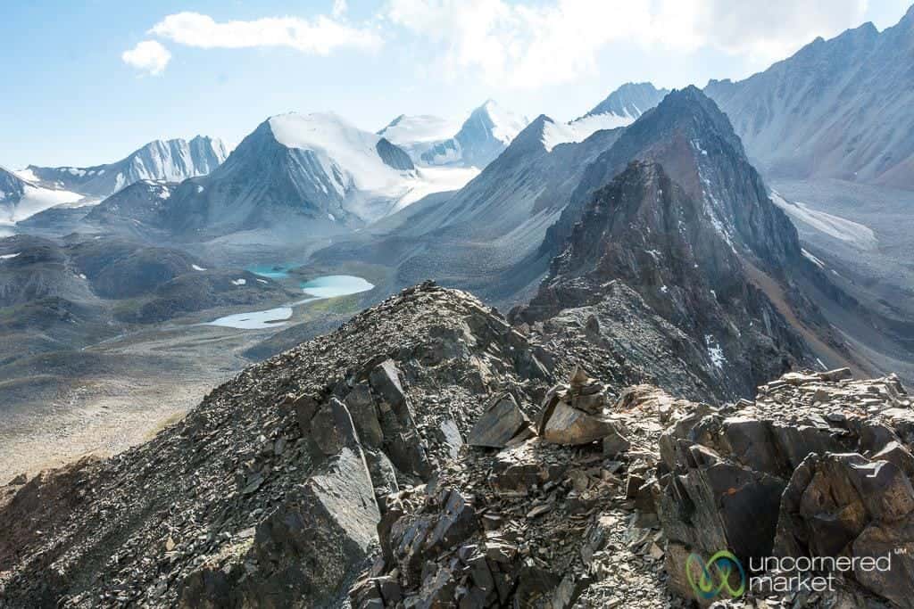
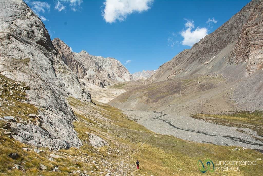
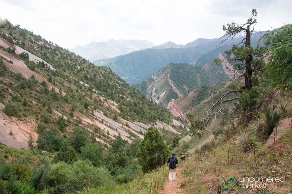
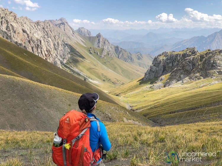
Although this is a long day of hiking, we were pleasantly surprised by the diversity of landscapes, geographic formations and colors. We jokingly called sections of it “The Best of Kyrgyzstan” as it was possible to see large red rock formations just along the trail, jagged snow-covered Pamir Mountain peaks in the distance, and the variegated array of high-, mid- and low alpine landscape across your field of view.
As you leave Kyzyl Shoro village you’ll leave the road behind and follow the trail as goes towards the right up a dry river bed and past several outlying homes and farms. People here are quite friendly so don’t be surprised if you’re invited for tea along the way.
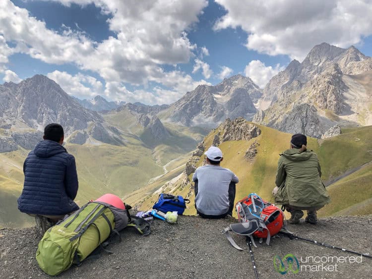
With the village and outlying homes behind you, the trail becomes very steep and ascends approximately 860 meters (2,820 feet) through grass meadows and pastures to Koshmoinok Pass (3,415 m / 11,205 feet). Remember to keep looking behind you. The views open up as you ascend.
After the pass, it's about a 45-minute descent to Koshmoinok Valley which is a beautiful setting and features layers of mountains on all sides. It’s worth taking a break here to enjoy the surroundings.
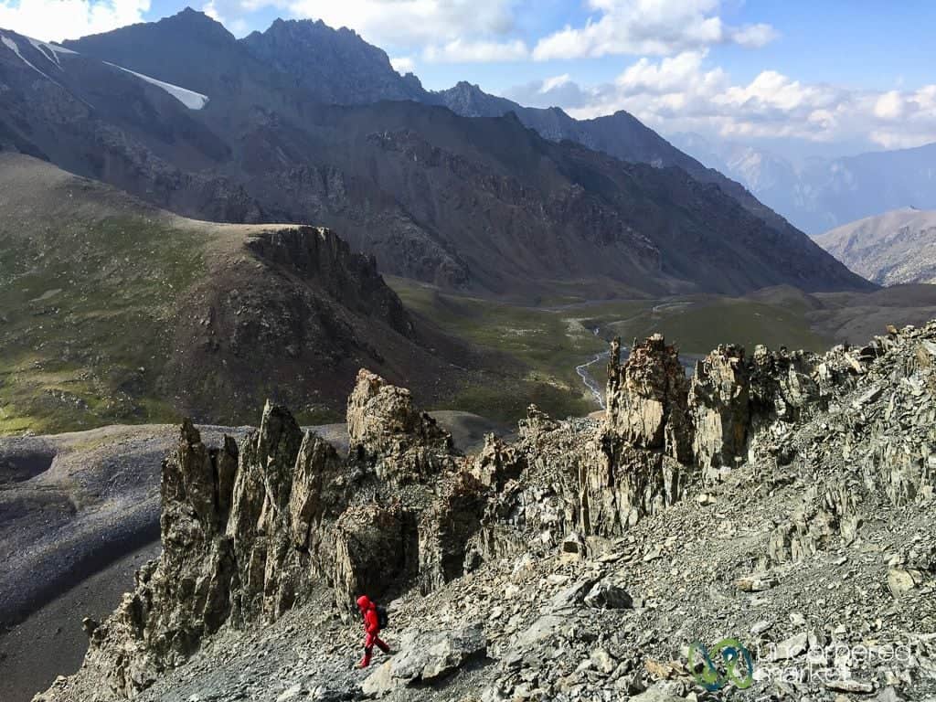
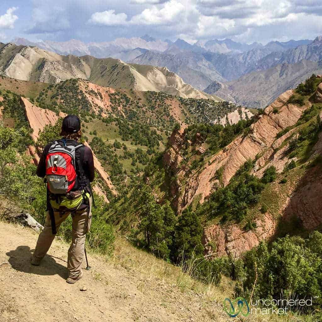
The day begins by following the river from the campsite with a moderate climb to Sarybell Pass (3,124 meters / 10,250 feet). From there, enjoy a beautiful view of the different layers, colors and landscape features of the Alay Mountains. From the top of the pass, continue left and follow the path as it winds along the edge of the hills with the valley to the right. Segments of this trail are steep and challenging due to scree and loose rocks.
Don’t forget to look down and across to your right as you enjoy the expanse of unusual red rock formations below, including a geological formation-feature we named “Three Dragon Gorge.”
The trail eventually reaches another grassy overlook where there are two options to Kojokelen village – straight and downhill or following the trail towards the left. Although the latter option is longer, we recommend it as it is less steep and the trail takes you around a valley filled with even more colorful and dramatic rock formations, from deep red to frost white and all natural shades in between.
The trail changes from scree and rock to a dirt path which cuts across and down into green fields and pastures. At this point, it’s best to use GPS markings or a map, as the trail can be difficult to find because of overgrown tall grass and brush. Eventually, you descend into Kojokelen village, passing a sacred cave and spring and crossing a bridge on the right hand side.
Once you reach Kojokelen village, you’ll have the option to eat dinner at a local guest house (we had a hearty meal at Mamatjakyp Guesthouse), take a hot shower and spend the night. Note: If you are doing the shortened version of the trek as we originally did, you can arrange a transfer to Osh (3-4 hours) that afternoon. Most trekkers, however, choose to spend the night in one of several guest houses in Kojokelen village to allow time to relax from the trek, take a hot shower, and return to Osh the next day.
Day 4: Kojokelen village – Yurt Camp
Hiking Distance: 10 km / 6.7 miles
Minimum / Maximum Altitude: 2,223 m (7,293 feet) / 3,048 m (11,205 feet)
Estimated number of hours: 3-4 hours
This is an easy day. Sleep in a bit to recover from the previous day’s long hike and take your time getting going in the morning. From the village, follow the dirt road on a relatively straight and steady trail with a gradual incline.
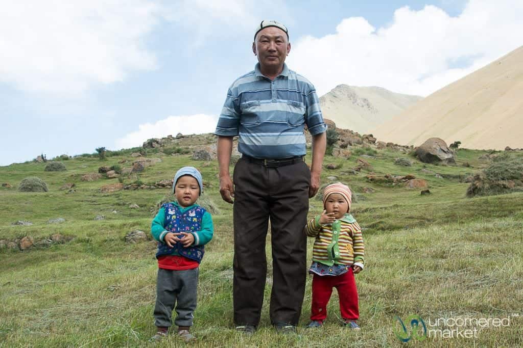
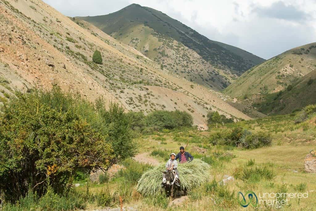
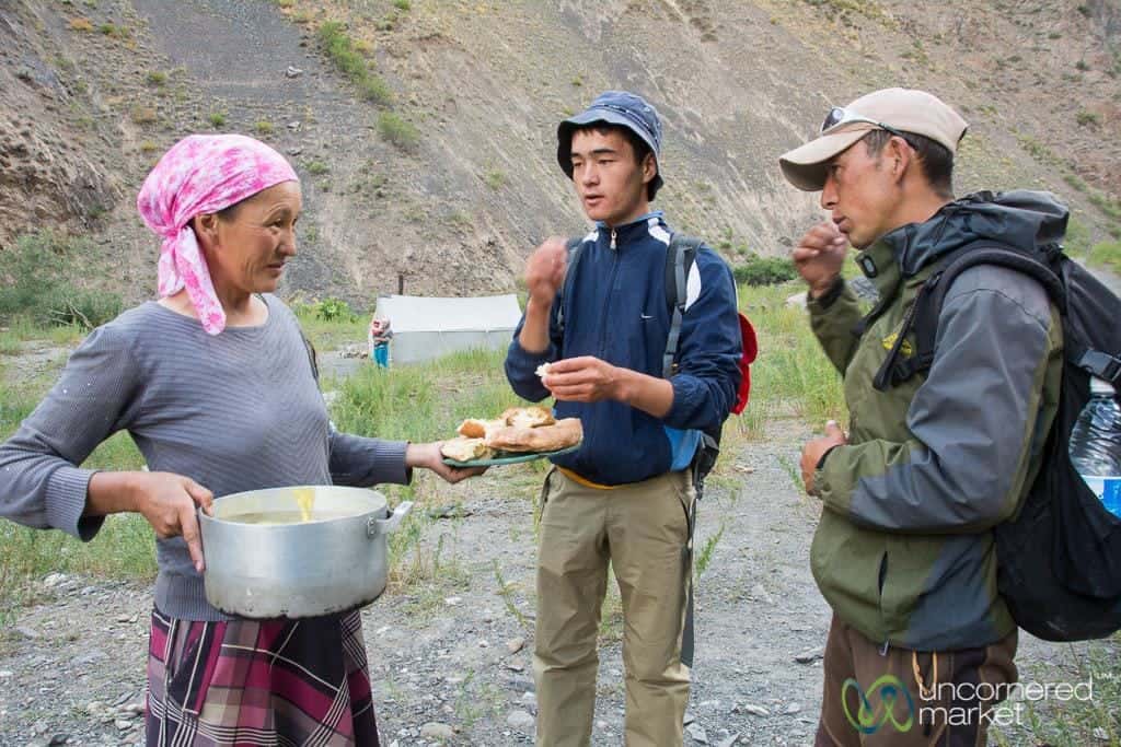
You’ll pass by herds of yaks, some of them cooling off in the streams. Shepherds tending their animals ride by on horses or donkeys. We also met several families fishing and spending time in the hills. Don’t be surprised if you are invited over for tea and bread as locals are curious and friendly.
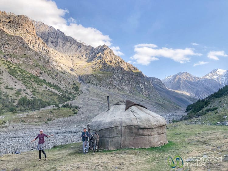
After a few hours you’ll arrive at the family yurt camp where you’ll be greeted with tea, borsok (fried bread), and other sweets. Eat and rest well as the next day is more challenging.
Day 5: Yurt Camp – Jiptick Pass – Darbazatash Valley Yurt Camp
Hiking Distance: 16 km / 10 miles
Minimum / Maximum Altitude: 2,962 m (9,718 feet) / 4,185 m (13,370 feet)
Estimated number of hours: 6-7 hours
It’s good to get an early start, not only because this is a relatively long day over Jiptick Pass, but also because the mountain views are clearer and more crisp in the morning light. Take it nice and slow as this will help you better adjust to altitude and give you adequate time to enjoy the views around you.
From the yurt camp, follow the dirt road and trail up and around over several hills and valleys. The terrain will transform into high desert, switching from grass to volcanic scree and rocks. Continue to follow the trail up the dark scree to Jiptick Pass.
At the top of Jiptick Pass take in the views of the snow-covered Pamir Mountains as they open in front of you. They appear like floating clouds above the high pastures and valleys below. Take a well-deserved lunch break here before starting your descent.
The descent is a bit tedious and requires caution. It’s steep and composed mainly of loose scree. Be careful with your footing to avoid slips, ankle twists or a fall (trekking poles are highly recommended). The trail eventually evens out to where you follow shepherds’ paths across the high pastures where they take their horses, cows, yaks and sheep.
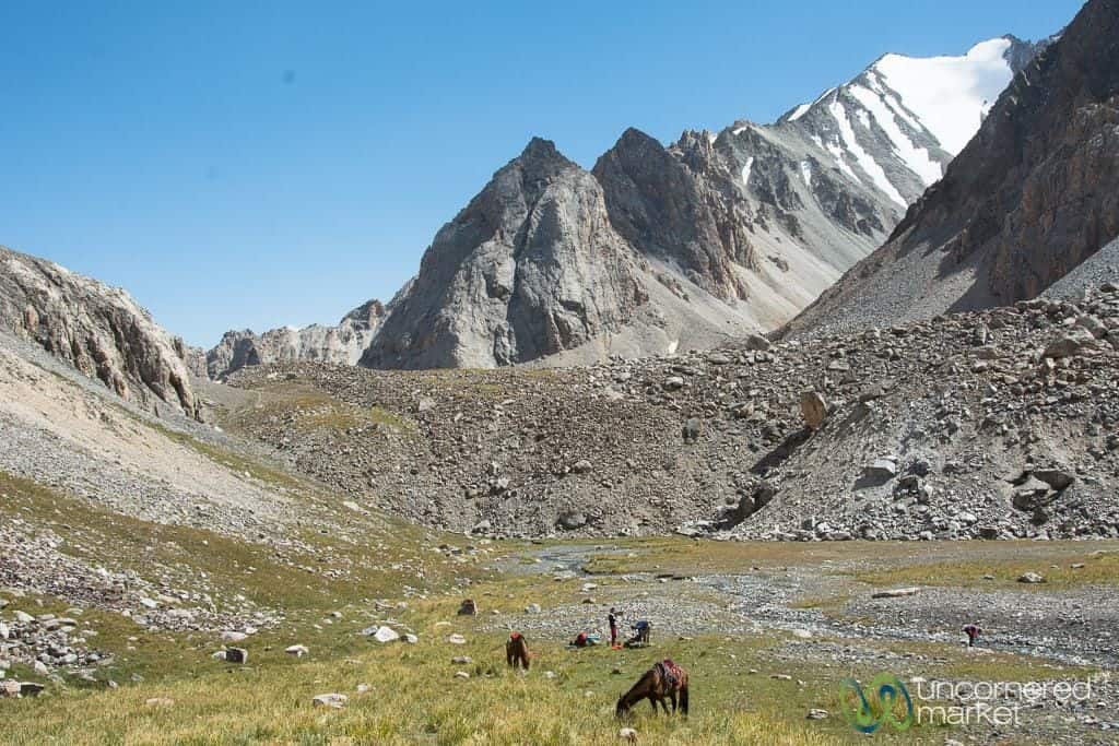
After a couple of hours you’ll arrive at the yurt camp located near a mountain stream. Consider soaking your feet in the frigid water for a minute or two to soothe them after the steep ascent and descent you just endured. We enjoyed a lazy afternoon at the yurt camp, lounging in the sunshine and playing games with one of the daughters.
Day 6: Darbazatash Valley Yurt Camp – Sary Mogul Village
Hiking Distance: 12 km / 7.5 miles
Minimum / Maximum Altitude: 2,962 m (9,718 feet) / 3,245 m (10,648 feet)
Estimated number of hours: 3-4 hours
This is another relatively easy day as you’re essentially walking out of the Alay Mountains towards Sary Mogul village. Along the way you’ll pass several other yurt camps and families with their animals.
Closer to Sary Mogul you’ll pass a huge coal mine, and a bunch of industrial trucks and machinery. Although the scene isn't particularly pretty, the coal mine does serve as an important source of employment and income in the area. In a high desert environment, there aren’t a lot of agricultural or income-generating options.
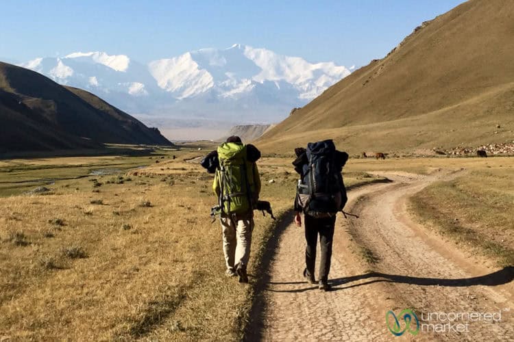
Continue along the road until you reach Sary Mogul village. From there you can spend the night at a local guest house, get transport back to Osh, or continue trekking in the Pamir Mountains as we did, via a transfer to Tulpar-Kol Lake (see below).
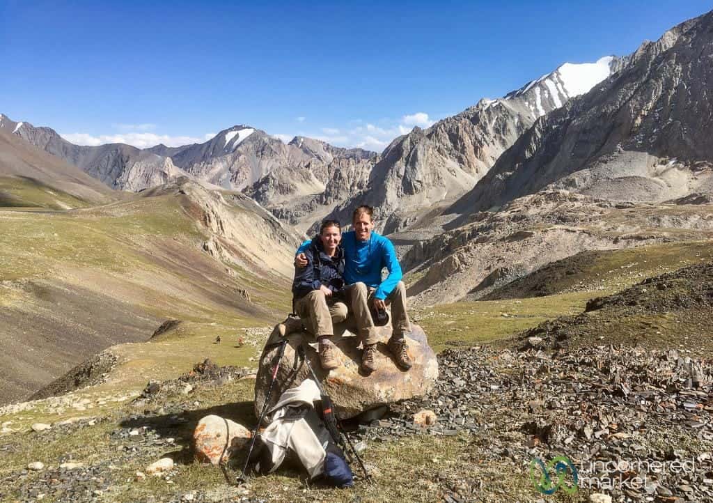
Optional Add-On: 2-3 days trek in the Pamir Mountains to Traveler’s Pass and Yuhina Peak
If you haven’t had your fill of the high mountain adventures, you can continue trekking for another 2-3 days into the Pamir Mountains on the new Visit Alay Best of Alay Trek. We did the full 2-day version all the way to Lenin Peak Camp 1 and Yuhina Peak (5,100 meters/16,730 feet) which is now part of the Visit Alay Lenin Peak Base Camp Trek (8 days). You can also reduce this to a day hike to Traveler’s Pass.
After arriving in Sary Mogul from the Heights of Alay Trek, you transfer to Tulpar-Kol Lake and spend the night at the yurt camp there. The next day, hike out to Traveler’s Pass (4,100 meters / 13,450 feet) for a phenomenal panoramic view of the Pamir Mountains and Lenin Peak (7,134 meters/23,405 feet). Be sure to go down to the grassy area below the pass as this features the best views. For the one-day trek (19km / 12 miles) you return back to Tulpar-Kol yurt camp for the night.
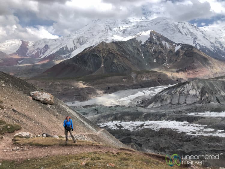
For those doing a two-day trek, continue on the trail another 4-5 miles/7-8 km to Peak Lenin Camp 1 for a total of 9.5 miles (15.3 km) on day 1. The narrow trail takes you through some high altitude multi-colored valleys that look like a watercolor painting and past layers of glaciers with snow-covered peaks all around you. This landscape is otherworldly, too — but different from the ones you see along the Alay Mountain treks.
Peak Lenin Camp 1 (4,400 meters/14,435 fee) is quite basic, but you’ll be provided tents (2-person) and hot meals. It's also an interesting view into the world of professional and serious alpinism and mountaineering. Most of the people staying here are en route to climb Peak Lenin (7,134 meters/23,405 feet). Try to get a good night’s sleep since the next day is a challenging and long one.

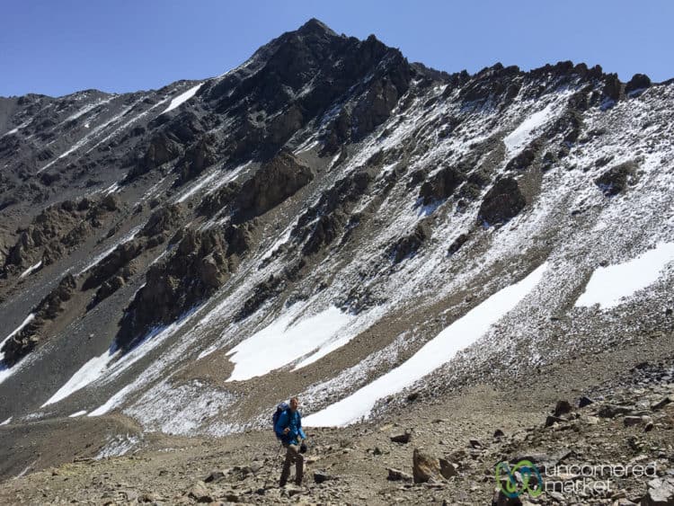
Wake up early (you may need to arrange an early breakfast time with the camp) and begin your ascent to the top of Yuhina Peak. It’s a slow climb up scree and switchbacks. And it’s very challenging. If you go very slowly and steadily you will indeed get to the top. And you will be rewarded there with some incredible views of the Pamir Mountains.
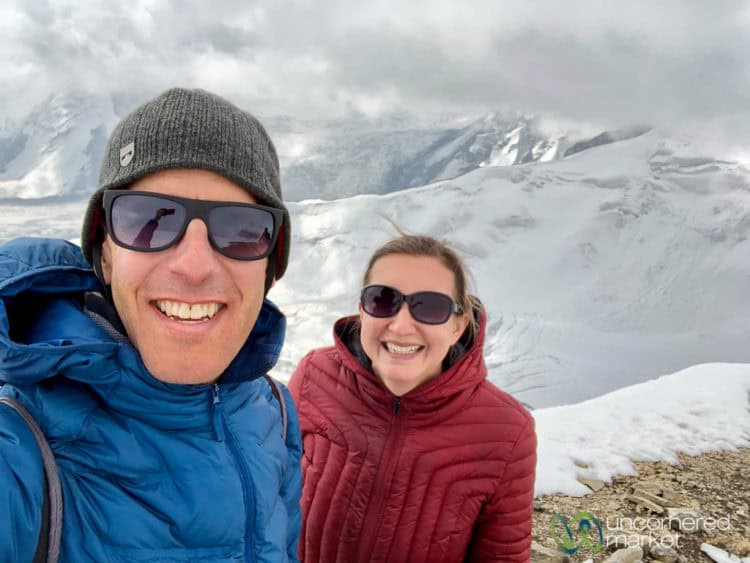
Be careful on the way down as the scree is soft, loose and steep. Take a break at Camp 1 to enjoy lunch. Continue the same way over Traveler’s Pass to Tulpar-Kol Lake yurt camp. You can spend a night there to recover or take a transfer to Sary Mogul to overnight there.
Note: Several trekking agencies from Bishkek run Lenin Peak Base Camps, as well as camps at higher elevations. Our two-day Pamir Mountains trek was arranged and all our accommodation was booked by Visit Alay in Osh. We stayed at Ak-Sai Camp 1 and found it well-run, clean and professional. It’s geared more towards professional climbers than day-trekkers so it has a bit of a hearty mountaineering atmosphere, complete with sun struck alpinists and gruffly-spoken Russian.
Costs for the Best of Alay Trek and other Treks
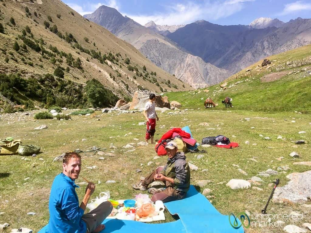
Our 8-day trek was a fully supported trek, which meant that all we needed to think about was our experience, carrying a simple backpack with clothes, and taking photos. We had local guides with us to ensure we didn't get lost; they also carried snacks and lunch items for us. They shared their knowledge of the Pamir-Alay Mountains, and of their lives and local culture. We were also well-fed from breakfast to dinner. (Disclosure: The costs of our 2017 trek were paid for by the USAID BGI tourism development project in conjunction with the consulting work we did and its trail-marking project. Our August 2019 trek was provided to us by Visit Alay as part of the Helvetas Bai Alai tourism development project.)
Our trek and local guides were organized by Visit Alay, the local CBT Kyrgyzstan branch in Osh. A portion of their profits goes back into community development and training of families in tourism and hospitality. Currently they are working with around 300 people in the Alay Region to provide travel services, accommodation, guiding and more.
2025 Prices for the Best of Alay Trek
The price of the trek depends upon the group size with 2 people recommended as a minimum group. The larger the group size, the less expensive it is as more people share the costs of transportation, guiding and other expenses. If you want to join an existing group to meet new people and reduce your costs, check out the Visit Alay small group trekking tours.
- Best of Alay Trek (8 days): $750 (2-5 people) – $650 (6-10 people)
Prices include: local guide, bed and breakfast (yurt or guest house), lunches and dinners, clean water and tea, transport from Osh and to/from trailheads. The price includes luggage carriage (usually by horse), but check the individual tour details to be sure.
Prices do not include: sleeping bag rental ($6/day), overnight stay in Sary Mogul village before/after trek, any special drinks outside of water and tea/coffee, which are provided.
Transport costs if trekking independently: Osh to Sary Mogul in shared taxi: approximately 400 som/person; Sary Mogul to trailhead: 1,500 som; Kojokelen to Osh: 3,000-3,500 som.
Scenic Ak-Tor Pass Trek: What to Expect on a Multi-Day Trek in the Lower Alay Mountains
We were introduced to the lower Alay Mountains during our visit in August 2019. Having been overwhelmed by other treks at higher altitude, we didn’t have high expectations for this trek. However, we proven wrong. We were surprised and impressed by this trek and its layers of hills, green valleys, granite peaks, and stunning viewpoints. The trailhead is located near Gulcha and about an hour outside of Osh so it’s a bit closer and more accessible than some of the other treks.
Although Visit Alay's Ak Tor Pass Trek is technically in the “lower” part of the Alay Mountain range (its northern side), it's still plenty high, crossing Ak-Tor Pass at 3,500+ meters/11,500+ feet. You still get a good trekking challenge and some really beautiful views of the entire Alay Mountain range. If you don’t have much experience trekking at altitude and want to do one of the high Alay or Pamir treks, this makes for an excellent and worthwhile acclimatization hike. You still get up to impressive altitudes during the day, but are sleeping at lower altitudes at night. Perfect for helping your body acclimatize and become accustomed to altitude.
You have the option of a range of treks in the area, running from two to five days — either by foot or on horseback. We did a three-day trek by foot, but we could see it being pleasant by horseback as the terrain features more rolling hills and fewer steep ascents than the terrain in the High Alay. The trails in the Low Alay also remain accessible for longer periods of time. You could even do this trek in late April/early May or in late September/early October when most of the other treks are closed because of snow.
Our Route: Trailhead near Gulcha – Sary-Oi Yurt Camp – Ak-Tor Yurt Camp – Ak-Tor Pass – Murdash Valley
Total Hiking Distance: 23 miles / 37 km
Number of Days: 2 nights/3 days (you can also do a 2-day trek or extend up to 5 days)
Minimum / Maximum Altitude: 2,195 m (7,200 feet) / 3,550 m (14,120 feet)
Season: June – early September
Difficulty: Easy-Medium
Day 1: Trailhead – Sary-Oi Yurt Camp
Hiking Distance: 13.75 km / 8.5 miles
Minimum / Maximum Altitude: 2,275 m (7,466 feet) / 3,580 m (11,744 feet)
Estimated number of hours: 4-5 hours
The walk begins in a the high pastures and passes by several shepherds and their animals on the hills around. As you begin to climb up take a look around an enjoy the a panoramic view of the valleys below. From this point, begins another ascent during which you'll cross a couple of mini-passes before you arrive at the main pass. At the very top you’ll enjoy a beautiful view in both directions — of the area you just came from and of the hills and valleys where you're headed.
Then begins the long walk down through and around various hills and fields. We didn’t expect it to be such a long way down. Expect a trail which seems to keep going and going. Eventually you will arrive at the yurt camp in Sary-Oi and be greeted with tea, snacks and a comfortable place to rest inside the yurt.
Day 2: Sary-Oi Yurt Camp – Yurt Camp at Base of Ak-Tor Pass
Hiking Distance: 10 km / 6 miles
Minimum / Maximum Altitude: 2,195 m (7,200 feet) / 2,700 m (8,868 feet)
Estimated number of hours: 4 hours
This is an easy day so sleep in and enjoy a leisurely breakfast. The only thing to consider is that it often rains in mid-late afternoon where the next yurt camp is located so try to time your arrival early enough to avoid getting wet (something we didn’t manage to do).
Follow the mountain stream through the valley to the next yurt camp. This is a popular place for animals to graze as its fertile and rich. You’ll meet more than a few cows along the trail. There are a couple of stream crossings that you’ll need to navigate. We’ve heard that small bridges should be built by the 2020 season to make these crossings easier. You’ll arrive at the next yurt camp in time to enjoy a leisurely afternoon of rest or reading.
Day 3: Yurt Camp – Ak-Tor Pass – Murdash Valley
Hiking Distance: 13 km / 8 miles
Minimum / Maximum Altitude: 2,195 m (7,200 feet) / 3,580 m (11,744 feet)
Estimated number of hours: 4 hours
Eat a hearty breakfast as you begin this day with the ascent up Ak-Tor Pass. It’s not exceptionally steep, but the trail features its share of switchbacks and climbs, making it a worthwhile challenge.
The views at the top of the pass and along its ridge are absolutely fabulous and serve as an excellent payoff. Take a break here to enjoy the granite peaks, green valleys and layers of mountains which unfold in all directions off the ridge.
The descent isn’t too steep, but you’ll still need to be careful with your footing as you make your way through long grass. Watch out for holes and other irregularities that could easily twist an ankle. You’ll continue down through the hills until you reach Murdash Valley, which is beautifully framed by granite peaks. Continue heading straight down through the valley, likely encountering a shepherd or two, until you reach the dirt road.
That’s where you’ll pick up transport to take you back to Osh. If you've opted for a five-day trek, you'll continue walking to the yurt camp nearby for an overnight.
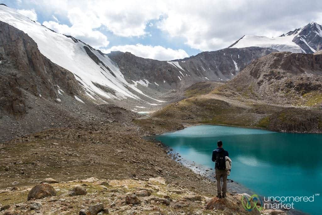
Koshkol Lakes Day Trek: What to Expect on a Day Trek in the High Alay Mountains
If you don't have much time and can't do a multi-day trek in the High Alay Mountains, we highly suggest the Koshkol Lakes Day Trek near Sary Mogul village. This day-trek is a sort of “best of the Alay Mountains” — turquoise alpine lakes, glaciers, views of the Pamir Mountains and Peak Lenin, gorgeous meadows, yurt villages and frolicking yaks — all in just one day.
Hiking Distance: 21.4 km
Minimum / Maximum Altitude: 3,528 m / 4,213 m
Number of hours hiking: 6-8 hours
Season: June – September
Difficulty: Medium
To get to the starting point of the trek, take a transfer from Sary Mogul village to Damjailoo yurt camp about 10 km up a dirt road from Kashka-Suu village. Be sure to get an early start so that you can maximize daylight.
It’s a relatively long walk and it’s worth it to take your time to enjoy the stunning scenery on the way to the pass, at the pass (4,195 meters) itself, and the snow-covered Pamir Mountains in the late afternoon light. If you have extra time, you can push a little bit past the pass to glimpse even more lakes and the glaciers above it.
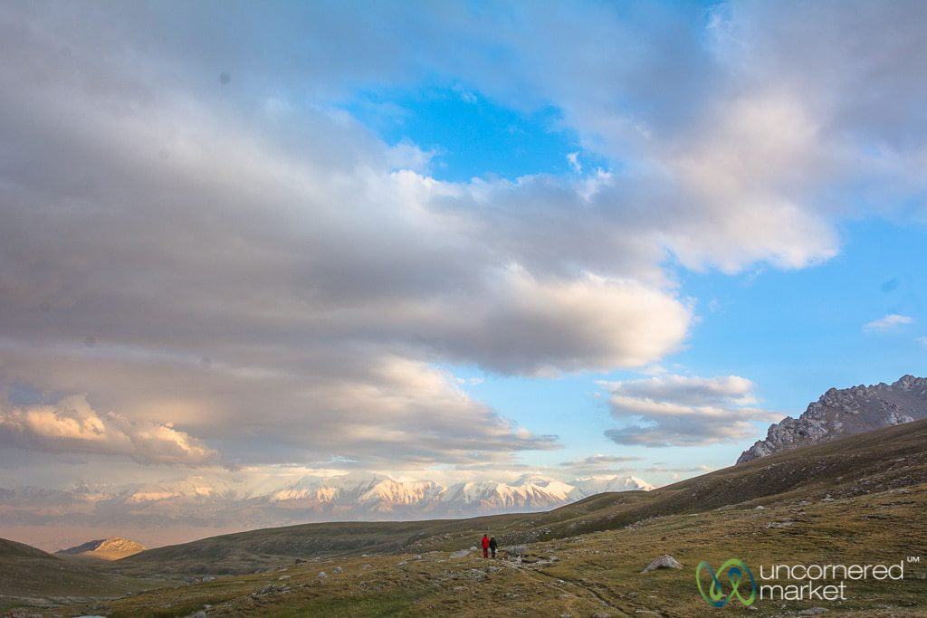
On the descent, Dan and I — individually, as we'd become separated — shared becoming emotionally overcome and overwhelmed to the point of tears with the sense of beauty and peace of the the final, long meadow you cross, just before descending into the shepherd's yurt village. This moment underscored for each of us how the world is filled with the immense, expansive power and beauty of nature. We were — and still are — filled with gratitude that places such as these exist, and that we've been among the fortunate (and few) to have experienced it.
Note: this trek can be expanded into an overnight trek which includes crossing another mountain pass and a seeing a total of seven alpine lakes.
Costs of the Koshkol Lakes Day Trek
These are 2018 prices so please get in touch with Visit Alay for updated prices as some costs and fees may have increased over the years.
| Price per person | 1 person | 2 persons | 3 persons | 4 persons | 5 persons |
|---|---|---|---|---|---|
| Koshkol Lakes Day Trek | $77 | $41 | $29 | $23 | $20 |
Prices above include: Round-trip transport from/to Sary Mogul village and the trailhead, local guide, food.
Note: If you want to do this trek independently without a guide, round-trip transport from/to Sary Mogul village costs around 2,000 som / $30 where the driver will wait for you at Damjailoo yurt camp.
When to go Trekking in the Alay Mountains
The trekking season in the Alay Mountains begins in early-to-mid June and runs until mid September. The high season is July and August when temperatures are warm and the mountain passes are fully cleared of snow.
By the end of August temperatures begin dropping considerably at higher elevations. Although some treks can technically be done in early September, be especially sure to pack additional warm clothing and layers for this time. If you can time it, we recommend going early in the season in mid-late June when wildflowers are blooming and everything is green. Having said that, it remains stunning through August, as our experience proved.
Both times we went trekking was in late August. The weather was excellent. Days were warm and sunny, and although it was cold at night at altitude at the campsites (close to 4,000 meters / 13,123 feet) it was comfortable as we were prepared with warm sleeping bags and plenty of warm layers.
Should I trek in the Alay Mountains independently or with a guide?
All of the Alay Mountain treks above can be done either independently or with a guide. Many of these trails and routes have been marked recently (keep a lookout for red paint) and are included in the new regional trekking maps (available at Destination Osh or Visit Alay offices in Osh city). However, these trails do take you into some rather remote and high altitude areas where it is easy to get lost.
Your decision whether to go on your own or hire a guide should include factors like: how much experience you have trekking in remote areas, your skill at reading trekking maps and/or GPS devices, the length of your trek, your budget, and weather. That said, never sacrifice safety.
Although our Koshkol Lakes and Heights of Alay treks technically could have been done without a guide, we were thankful to have one with us. This provided us with peace of mind that we were on the right path (as some of you may remember, we have gotten lost in the mountains before).
Having a guide allowed us to focus on the experience. We avoided having our nose in a physical map and on digital tracks, worried about taking the wrong trail. Not to mention, it was nice to have horses carry our gear rather than having to deal with heavy backpacks.
In addition, our local guide provided local context and a stronger connection to local people and culture. We asked questions of our guide, regarding his experience growing up in these mountains and recent changes he'd seen in environment, culture and economy. Some of the areas where we trekked had local shepherds and yurt camps, and we were often invited in for tea, bread or other snacks. Our guide acted as a sort of cultural ambassador, and served as an interpreter so we could ask questions and engage in deeper conversations.
While trekking independently in the Alay Mountains may save you some money and perhaps allow you a little more flexibility of schedule, local guides are immensely helpful. In addition, we knew that the money we spent was going to support local people and communities, directly and indirectly.
How to Organize Your Alay Mountains Trek: Trekking Agencies, Guides and Options
We'd recommend going with a local trekking agency. They know the area well and work with local guides. The closest big city to the Alay Mountains is Osh, which can serve as a planning and organizing hub.
Travel to Osh, do your research, visit local tour operators (we've trekked with and recommend Visit Alay), and make your trekking arrangements. There is also a CBT office in Sary Mogul that can help you organize treks, find homestays, and hire guides and horses.
If you are traveling to the Alay Mountains region from Tajikistan (e.g., Pamir Highway) or China consider making arrangements in advance so that you don't end up back-tracking. In this case, it makes more sense to stop off in Sary Mogul or Sary Tash on your way to Osh and do your treks directly from there.
If you are trekking during high season (July-August), send a few email inquiries in advance to be certain that trekking agencies are not already at capacity with their guides, tours and rental gear. We heard that Visit Alay and some of the nearby CBT partners were expanding their inventories of trekking gear (e.g., tents, sleeping bags, mats, backpacks, cooking stoves, etc.) so hopefully this will be less of an issue in the future.
Our trek was organized by Visit Alay, the Osh branch of Community Based Tourism Kyrgyzstan. We were really happy with our experience and the level of service.
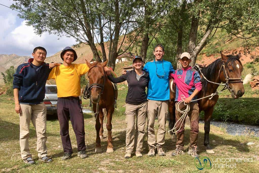
The manager, Talant, is from the Alay Mountains himself and knows the local communities well. In fact, as we trekked with him he would greet all local families along the way. They talked with him about what we were doing and if the families might want to become involved by offering accommodation (e.g., yurt stays), meals or other support. All the tours and treks through Visit Alay use local guides, and a portion of their profits goes back to the community. (Disclosure: Our trek was organized for us and paid by the USAID-BGI tourism development project as we were helping to mark the trails.)
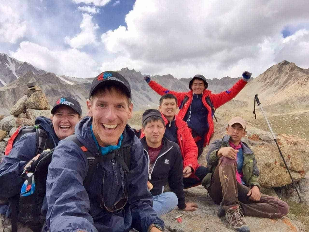
Because we were also marking the trails at the same time, we had two guides on our trip. We can recommend both of them. Aziret grew up in a village in the Alay Valley, but is currently based out of Osh since he is studying foreign languages at university. He guides during the summer to support his eduction. Ubai is based in Sary Mogul and knows all the mountains in the area like the back of his hand. Both are pretty good cooks, too. Update September 2019: Aziret is now working in the Visit Alay office in Osh so he is no longer guiding. However, we had Timur as our trekking guide during our recent visit and he was also great during the nine days we were together in the mountains and in villages.
They took good care of us, always making sure there was hot water for tea or coffee. They had abundant snacks on hand any time we looked hungry. They are also both horse experts, and were very adept with pack horses, especially over some of the very difficult mountain passes.
Help your guide help you. Make sure that you let the trekking agency and guide know in advance of any medical needs you might have, as well as any dietary restrictions. This will allow your guide to purchase the right type of food and snacks for you. Many of the trekking guides recently completed additional culinary training for mountain treks, so they ought to be well prepared to cook vegetarian, vegan, gluten-free and other styles of food.
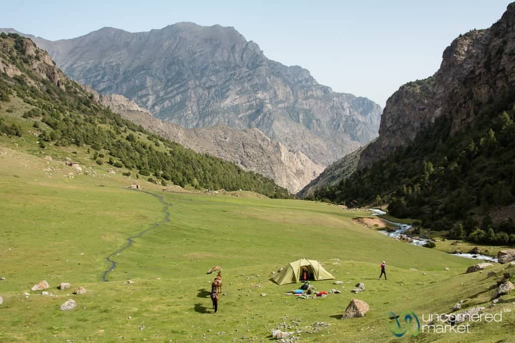
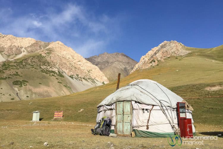
Accommodation and Sleeping Options in the Alay Mountains: Camping and Yurt Stays
Some treks will give you the option of either camping or yurt stays (staying with local shepherds and their families on the jailoo). Some combine the two accommodation options in one trek. Here are the advantages and disadvantages of both.
Camping: The primary advantage of camping is that you have more flexibility of where you can spend the night, which may allow you to reach more remote areas. The down-side: when temperatures drop, you need to be prepared.
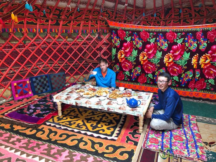
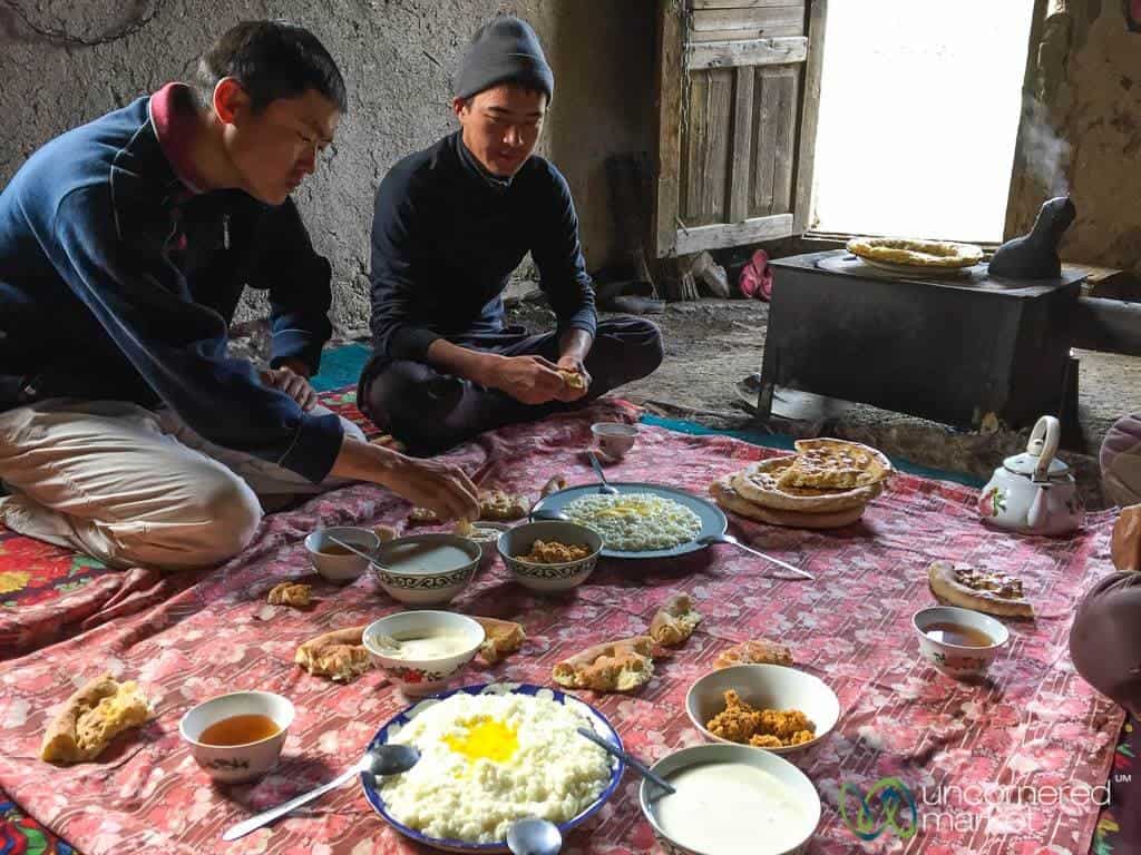
Kyrgyz yurt stays: All the main Alay Mountain treks now have a network of yurt camps so you can spend all the nights in yurts. These are usually offered by shepherd families where you are in a separate yurt set up solely for trekkers. We recommend you take this option as you'll have more opportunity to interact with local people and you won't have to carry tents, food or camping equipment.
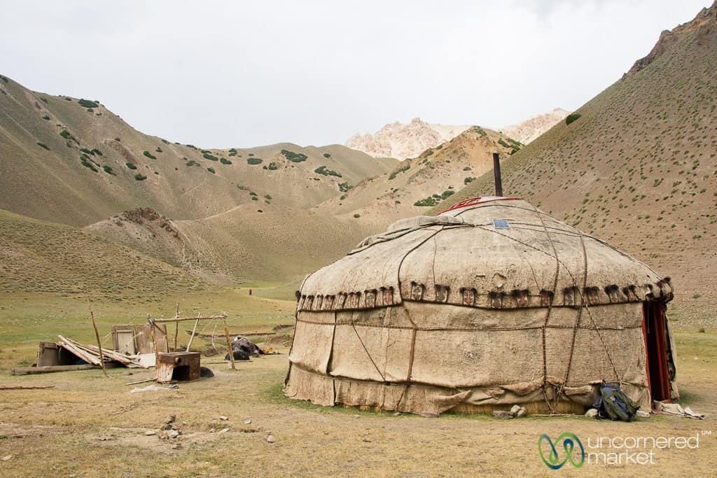
The advantage of yurt stays is that you have more opportunity to engage with local people and culture, eat a hearty home-cooked meal, and sleep inside (i.e., usually warmer). Also, you know that your tourism money is contributing to the income of the local family.
What to expect in a Kyrgyz yurt stay:
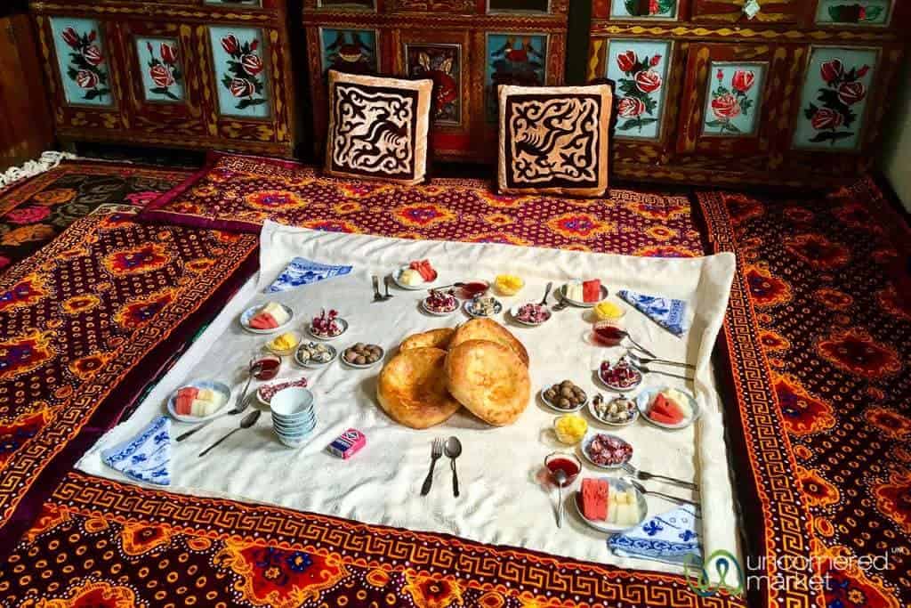
- Home-cooked meals: Food will be hearty and plentiful. Almost every meal includes some type of homemade bread, fresh dairy products (e.g., yogurt, sour cream, milk, etc.), local honey and jams, and tea. Lunch or dinner usually features some sort of meat with rice or potatoes.
- Sleeping area: Sleeping in yurts usually consists of a thin mattress or mat on the ground with lots of blankets piled on top. Typically 6-8 people will share a yurt. Carry a sleep sack with you.
- Toilets: Either don't expect any as you're out in nature or expect a makeshift outhouse. Either way, always have some tissues on hand and bring a headlamp for any nighttime toilet trips.
- Drinking water: Yurt camps will provide you with boiled water if you request it so you can easily refill your reusable water bottle or water bladder. We recommend carrying water purification drops or a SteriPEN with you just in case. This way, you'll always be assured of having clean drinking water with you.
Costs for Trekking in the Alay Mountains
If you wish to trek independently or with only limited support, a price list of guides, horse porters, camping gear, and accommodation follows. Note: Although the prices listed are from Visit Alay, we hear that prices are similar at CBT Sary Mogul and other local agencies.
2025 prices for these treks and hikes in the Pamir-Alay Mountains:
The price of the trek depends upon the group size with 2 people recommended as a minimum group. The larger the group size, the less expensive it is as more people share the costs of transportation, guiding and other expenses. If you want to join an existing group to meet new people and reduce your costs, check out the Visit Alay small group trekking tours.
- Best of Alay Trek (8 days): $650 to $750
- Heights of Alay Valley Trek (6 days): $550 – $740
- Peak Lenin Base Camp Trek (8 days): $750 – $1.090
- Ak Tor Pass (3 days): $240 – $330
Accommodation Costs in the Alay Mountains and Sary Mogul
It seems like pricing is pretty standardized at 1,000 som ($15) a person for sleeping, dinner and breakfast at yurt stays and guest houses in the Alay Mountains. If you're sleeping in your own tent, but want a home-cooked meal, costs run about 300 som ($4.50) for dinner or lunch, and 250 som ($3.70) for breakfast.
Many treks in the Alay Mountains set off from Sary Mogul village so you'll need to arrange accommodation there the night before. There are a few basic guest houses and homestays there, usually with shared rooms and bathrooms. Visit Alay or CBT Sary Mogul can help make a reservation for you as most do not currently support online booking. The basic price is similar at 1,000 som ($15) for a bed, dinner, and breakfast.
Transport: How to get to the Alay Mountains
The Pamir-Alay Mountain region in southern Kyrgyzstan lies at the crossroads of China, Tajikistan and Uzbekistan. The city of Osh is Kyrgyzstan's second largest city, and offers the widest support for the Alay Mountains (if you are already in Kyrgyzstan or coming from Uzbekistan). However, if you are coming from China or Tajikistan, you might wish to stop off in Sary Mogul or Sary Tash on your way to Osh and organize some treks along the way.
How to get to Osh City
Flying to Osh
The fastest way to get to Osh if you are already in Kyrgyzstan is to fly there from Bishkek. It's a quick 45-minute flight over some stunning mountain ranges, so try to get a window seat. We used Skyscanner to price and book flights from Bishkek to Osh.
In the summer months there are also direct flights from Tamchy Airport (IKU) on the north shore of Lake Issyk-Kul, which is a better option if you're coming from Karakol, Jyrgalan, or South Shore.
The are also direct flights to Osh from Moscow, Novosibirsk and a few other destinations. You can check the full schedule of flights to/from Osh airport here.
Land Transport: Buses, Shared Taxis and Public Transport to Osh
Shared taxi from Bishkek: Shared taxis to Osh leave from the Western Bus Station in Bishkek throughout the day. The cost is around 1,000-1,200 som/person. It's a long journey (10-11 hours), but you'll be rewarded with some beautiful views at the Toktugol Reservoir and over several mountain passes. No marshrutkas are allowed on this route because of safety.
Transport to Osh from China (Irkeshtam Border Crossing): It's best if you can arrange bus transport for the entire journey. If you can't, there are usually shared taxis hanging around the Kyrgyz side of the border that can take you either to Sary Tash (where you can then catch a marshrutka to Osh) or directly to Osh (4-5 hours).
Transport from Uzbekistan (Dostuk Border Crossing): Fortunately, the border with Uzbekistan is only 10km from Osh so this is an easy transfer. There are always oodles of shared taxis and marshrutkas at the border waiting to take you to the center of the city.
Transport from Tajikistan (Kyzylart – Bor Dobo Border Crossing): Travelers usually travel this way as part of their Pamir Highway road trip. Public transport is limited to none around the border area, so it's best if you arrange transport in advance to take you either all the way to Osh, or at least to Sary Tash or Sary Mogul. From those villages you can always catch onward public transport.
How to get to the Alay Mountains from Osh
Many of the treks in the Alay Mountains use Sary Mogul or Sary Tash as a base. Both villages are accessible by public transport from Osh either by marshrutka or shared taxi.
Trekking Packing List for the Alay Mountains
Much of what we include in our How to Pack for a Trek article still applies here. However, we offer a customized Alay Mountains trekking packing list to ensure you have what you need to be comfortable in the mountains yet don’t overpack.
Since there is now a network of yurt camps on the different Alay Mountain trails there is no need anymore to carry sleeping bags, tents or other camping gear. However, this does mean that you will need to carry a backpack with your clothes and basic toiletries.
Recommended trekking backpacks
Women's recommended backpack: Deuter ACT Trail Pro 32 SL Backpack: I love this backpack. It's very light with all sorts of great functionality like a built-in rain cover, water bladder compatibility, wide waist belt for stability, and more. Buy on Amazon | Buy on REI
Men's recommended backpack: Osprey Packs Exos 38 Backpack: This backpack comes in several sizes, and the Large version is well-suited for tall people (like Dan). Light, comfortable, and durable. Buy on Amazon | Buy on REI (48-liter)
Clothing
You really don’t need much in this department. Don’t worry about wearing the same thing every day. Everyone does it. It's more about having the proper layers as the temperatures may fall quickly at night. Here’s what we suggest:
- 1 set of hiking clothes: T-shirt (preferably quick dry), long-sleeved hiking shirt ( (his and hers) or pullover, shorts or trekking pants, hiking socks.
- 1 set of evening clothes for sleep: T-shirt, long pants (or pajama bottoms), socks. To ensure these remain dry, pack them in a plastic bag or other impermeable container inside your backpack.
- Ski hat and gloves: This may not be necessary earlier in the season, but by late August we were very thankful to have these.
- Underwear for every day of your trek: With an extra pair thrown in for good measure, if you like. Recommended his and hers
- Extra pair of socks: Just in case you want to switch out or it's freezing and you need an extra layer to stay warm in your sleeping bag.
- Fleece or other shell jacket: For cool nights or sleeping.
- Rain or windproof jacketI upgraded to a NorthFace Climatech technology waterproof jacket recently and I love it. It not only provided protection against the rain and cold, but the jacket material is very breathable so it didn't feel like a sauna inside. Highly recommended. Buy at REI | Buy on Amazon.
- Down jackets: We've also started carrying a light down jacket that can be stuffed into a tiny cinch bag. It hardly takes up any room or weight in the backpack, but can provide warmth and comfort at night when temperatures drop. Dan loves his seamless ultra-light down jacket from Uniqlo.
- Waterproof Poncho (optional): Just in case it rains. This one covers your backpack for additional protection.
- Waterproof pants: Hopefully you won't need these, but better to be safe than sorry. We carry a pair of light pull-on biking waterproof/water resistant pants. They fold up into a small bag so they barely take up any room or weight in your backpack, but keep you quite dry when the clouds open up.
- Thermal underwear (top/bottom): If you're trekking either early or late in the season, consider bringing along some silk long johns as they are warm, comfy and take up almost no room at all.
- Hiking shoes: Low-rise hiking shoes are fine. We both recently shifted to wearing Oboz Sawtooth hiking boots. The insoles and support for your feet are really good, and the shoes are sturdy and can stand up to some tough terrain. In addition, Oboz plants a tree for every pair of shoes sold so you can feel good that your purchase is going towards reforestation and environmental projects. Men's Obuz Sawtooth Hiking Shoes: Buy at REI | Buy on Amazon. Women's Obuz Sawtooth Hiking Shoes: Buy at REI | Buy on Amazon
- Flip flops or river shoes: At the end of a long day of walking you may want to take off your hiking shoes and give your feet a rest. But you'll still need something on your feet to go to and from the yurt to the outhouse. That's where flip flops or river shoes worn with socks (yes, ignore the fashion police) are perfect. Buy on Amazon (Women's) | Men's River Shoes
Other Trekking Gear
- Refillable water bottle or water bladder: Refill your own water containers with boiled or purified water instead of carrying bottled water and leaving a trail of plastic wasted. We also recommend carrying water purification drops or a SteriPEN with you so that you can always be assured of having safe drinking water with you.
- Walking stick: Highly recommended, especially for downhill sections through slippery scree. We usually share one walking stick set of two so each of us uses one stick.
- Waterproof backpack cover: You never know when a rainstorm will hit, so it’s essential to keep a rain cover for your backpack close at hand.
- Quick-dry travel towel: To dry off your hands or face after washing it in the stream.
- Sleep sack: To provide an extra layer between you and the piles of blankets. Plus, this helps keep you warm if the temperatures drop at night.
- Headlamp: The yurt camps do not have electricity or lights outside. Carry your own headlamp to find your way to the toilet and to sort through your stuff at night in the yurt if it doesn't have a solar light.
Toiletries and Health Kit
You won't have access to a shower for several days at a time, but you don't really miss it as the evenings and mornings are quite cool. You will have access to fresh water everywhere to wash your face and hands.
- Soap, toothbrush, toothpaste, dental floss: You know, the basics. And don't laugh at us that we put dental floss as a basic. You'll thank us after eating a meat-heavy meal.
- Sunscreen: The higher the SPF, the better. At this altitude the sun is very powerful.
- Sunglasses: Necessary. That sun is darn strong.
- Hand sanitizer: To be on the safe side.
- Pack of tissues or roll of toilet paper: There were rolls of toilet paper available in out houses, but it’s always a good idea to carry your own…just in case.
- Duct tape: Effective for hot spots and blisters on your feet.
- Medical Kit (for emergencies): Band-Aids, anti-bacterial gel (for cuts), rehydration powders, ciprofloxacin (or another medication against stomach bacteria), Tylenol (anti-headache/aches), Immodium (or some sort of “stopper” if you get diarrhea). Note: All this can be easily and inexpensively purchased at local pharmacies in Osh.
Electricity and Charging Batteries
You will have access to electricity when you stay in guesthouses in Kyzyl Shoro and Kojokelen villages, but prepare yourself for having limited to no electricity at the yurt camps. Although some yurt camps do have solar panels the level of charging ability varies. Some tips to handle this and further your battery power.
- Put your smartphone on airplane mode. There is no connectivity along the trek anyhow, so don't waste your phone’s battery power trying to find a network.
- Consider buying a phone case that doubles as an extra battery. Here’s an example for our iPhone X battery case. Alternatively, you could carry a Mophie charger or solar powered power bank. They all provide another 1-1.5 charges.
- Take an extra camera battery or two.
- Don’t spend time reviewing your images on your phone or in the camera viewfinder, as this will quickly consume battery power. Unless you are reviewing images to determine whether you’ve captured a specific shot, there will be time enough for photo review when your trek is finished.
Still have questions about the Alay Mountains and trekking in the region? Please ask in the comments below.
Hi Audrey, I would like to see the Pamir glacier via a hike from Tulpar Kol Lake this summer. I will go with my daughter (15 years) – so the tour should not be too difficult (she is really tough and we did a longdistance tour before – but not that up in the mountains) . Do you think this will be a good idea or is it too difficult even if we book a tour with a horse to carry our luggage? And is it safe, for we are mother and daughter travelling alone?
Thank you very much for your answer – your website is extremely helpful!
Joe
Hi Joe,
That sounds like a great trip with your daughter! If neither you nor your daughter have experience at high altitudes I’d suggest perhaps spending a day at high altitude acclimatizing (e.g., perhaps in one of the nearby villages) before starting the hike. I haven’t done this trek myself, but I don’t think it would be too difficult for you both, especially if you hire a horse for luggage and support. I would contact Talant at VisitAlay.com and explain your situation and ask his advice since he knows all these trails very well.
As for safety, we’ve never encountered any issues in this area and we find people in the Alay Region very friendly and hospitable. And, if you have a guide with you that will prevent you from getting lost and he will also be there for support if there are any medical or other issues.
Good luck and enjoy your hike!
Just off the top of your head, what trails would you use to put together a 200-mile, or so, trek through the region?
Also, logistically, I imagine that with a little extra planning, carrying out a trip of this length to possible. What do you think?
Thanks! Great feature – best one out there.
Rob, I’m afraid that we’re not so experienced in the region to be able to piece together trails for a 200-mile trek. My suggestion would be to get in contact with Talant from Visit Alay as he knows the region well and also has a team of local guides who know it even better. They would probably be the best people to advise.
Alternatively you could take a look at Wikiloc to see what trails are uploaded for the region and see if you can begin to piece together something there that would take you through Kyrgyzstan or possibly into Tajikistan (although, border crossing might be tricky).
I imagine it would be possible to put together a trip of this length with a bit of planning to see where villages are to stock up on food, water sources, etc. One person who has walked through this region for thousands of miles is Paul Salopek on his Out of Eden project. He used local guides and donkeys to help with his journey, but then again he’s walking 21,000 miles around the world. Here are his dispatches from Kyrgyzstan, Tajikistan and other areas along the Silk Road: https://www.nationalgeographic.org/projects/out-of-eden-walk/the-journey/chapters/4-silk-roads
Hi Audrey,
first of all thank you for this incredibly detailed guide which helped me a lot planning my Kyrgyzstan adventure!
I do have a couple of open question though, I was hoping you could help me with.
I am flying in to Osh Mid August, then planning on going straight to Sary Mogul and start a self-guided trekking tour through the Alay Mountains. I am experienced in remote backcountries, well equipped and fit.
However Í have no experience in high altitudes for an extended period of time. I am planning on staying two nights near Sary Mogul for acclimatisation, before departing for the “Heights of Alay” trek. From your experience – do you think this will be enough? Did you encounter problems with altitude sickness when doing the trek?
Also, can the trek be done without a GPS, just by navigating through signs and / or a map and compass?
And lastly – would you recommend booking transport (eg to the trailheads) in advance or can this be done locally on short notice?
Thanks in advance for your help!
Best
Robin
Robin,
Glad you found our guide and article helpful for your upcoming trip to the Alay Mountains and Kyrgyzstan. As for your questions:
1) I think two nights for acclimatization around Sary Mogul would be sufficient. To be extra careful, ask CBT or your guesthouse about a day hike in the area that will take you up in altitude during the day and then you’d sleep at lower altitude (Sary Mogul) at night. We did not have any trouble with altitude sickness during our trek, but we also had experiences in Nepal, Tanzania, Peru and a few other places at altitude.
2) If you have experience in the mountains you will likely be fine with a map and looking for markings (although, some of the paint might have rubbed off by now). To be extra sure our suggestion would be to download the Wikiloc GPS digital tracks for the trek — they are linked in the article — and then use them with a smartphone app like Wikiloc or PocketEarth (what we usually use). Both of these can be used when you don’t have a mobile signal. That way you can always double check the digital tracks to be sure you’re on the right path or trail. You can also buy physical trekking maps of the area at either Visit Alay or Destination Osh in Osh city before you go.
3) You should be able to book transport to the trailhead locally and at short notice. But, it might be worth getting in touch with Visit Alay and/or CBT Sary Mogul in advance to see if anyone else is going out that day so you can share the cost of the transport.
Have a great trek!
Audrey
Hi Audrey. I’m thinking of booking a trek in the Alay Mountains, but I noticed that while the trip from Osh to Sary Mogul is only 4hrs, the elevation jumps from around 1000masl in Osh to 3000masl in Sary Mogul. How common or serious of a problem is altitude sickness among guests when first arriving in Sary Mogul from Osh?
Hi Jolo,
We haven’t heard of any serious problems of altitude sickness for travelers arriving in Sary Mogul from Osh. However, if you don’t have experience at altitude (in general or in other travels in Kyrgyzstan) then my suggestion is to take it slow. Spend a day or two in Sary Mogul to acclimatize before going on a trek that will take you higher in elevation. Do some walks around the village or a nearby day hike to help your body adjust to the altitude. This is especially important if you’ve just arrived in Kyrgyzstan and are dealing with jet lag at the same time (we know from experience that jet lag and high altitudes are not fun).
Good luck and have a great trip!
Hey Audrey, thanks for the great write-up. Much appreciated.
I’d like to add a note for independent hikers to the 6-day Heights of Alay Trek, from which we just returned. Maybe it’s because of Covid, but 2 of the yurt camps did not exist. No yurt, no people.
No problem for us as we carry our gear, but those who don’t might want to check in with the CBT in Sary Mogul before heading out to ask them to check (and make reservations?) first.
For experienced hikers, the trail is perfectly doable using the gps track. No guide needed (but who can add a lot of other value to the hike, of course).
Hi Audrey/ Scott,
Thank you for your useful content. I am really keen to get to Sary Mogul Pass and the “Watercolour Mountains” – but I suffer from serious altitude sickness which makes trekking difficult. Do you know if these areas area accessible via motorbike (the mountain type). Many thanks for your help.
Hi There! Thanks for the great write-up. Do you know how late into the year the yurt camps are open for the Heights of Alay Trek
Hi Travis,
Usually the yurt camps are open until early September, but this will be adjusted earlier or later based on weather. We’ve done the Heights of Alay trek in late August and the yurt camps were fully open. Hope you enjoy the trek! The Pamir-Alay Mountains are a special place!!